Forecasting of the Traffic Situation in the Hannover Region
The main requirement of road traffic participants is to know the current traffic situation. Such data is typically obtained from routing services where the time of many different individual trips is taken into account.
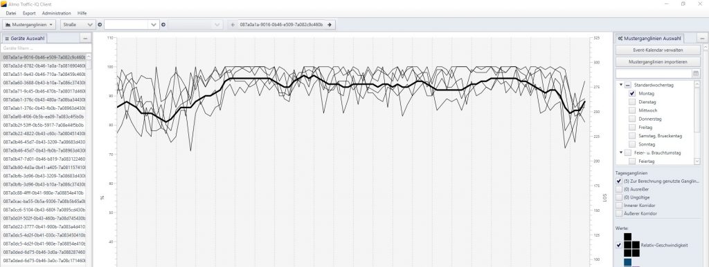
In the context of Data4UrbanMobility tools were developed that allow to predict the traffic situation based on such time series data. The following figure presents an interface to visualize typical time series patterns as well as outliers present in the data:
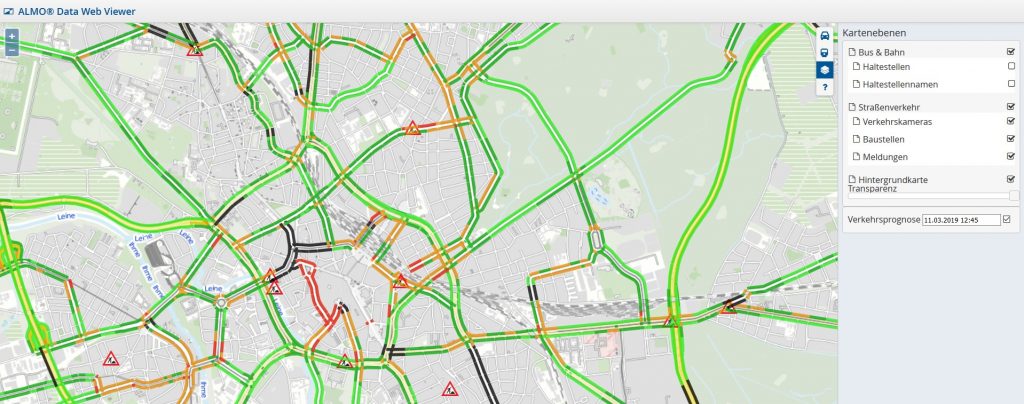
The prediction of the traffic situation is made available in the form of a map based interface for the end user:
Data4UrbanMobility Data Protection Regulation
The work on the Data4UrbanMobility data protection regulation is completed. The document is publicly available and can be found here.
First Version of MiC-App Available
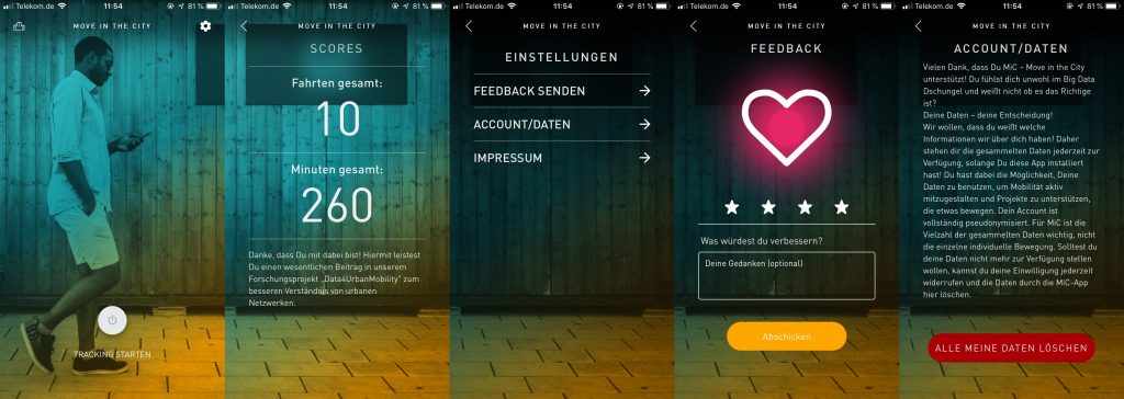
A first version of the novel MiC-App (Move in the City) App is now available for D4UM-associates as well as a protected group of public users. The mobile MiC-App is a tool to gather data.
MiC was developed by the Institute for Sustainable Urbanism at the University of Braunschweig and the Projektionisten GmbH. MiC links the growing awareness of digital citizen rights with the potential of evaluation big datasets. Therefore MiC gives the opportunity to citizen to actively participate in a citizen science project to take part in the development of the mobility of the feature.
MiC gathers data of the users movement, where the user has the about which data should be recorded. All data is pseudonymised such that the privacy of the contributing citizen is ensured.
Current Status:
In the first version of the app, the user can easily start and end the tracking of his/her movement. It is worth to point out, that the user decides when he is tracked and when not. A summary of his/her activity is available for the user as well as the opportunity to issue feedback or even delete all of his contributed data.
Updated System with Dashboard V2
With the new version of our system, the dashboard will provide even more insights into the impact of public events on the traffic situation.
The coloring and labels let us easily distinguish between the different type of events. By clicking on the label we show the typically affected subgraph for that event type. This allows the user to check what specific routes are typically affected by an event at that location.
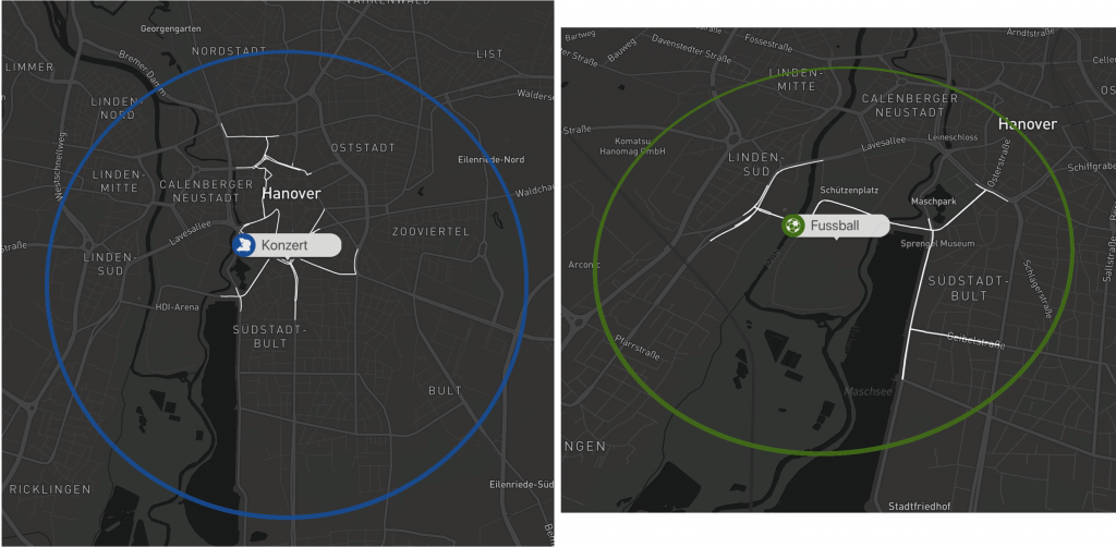
Examples: Visualisation of a concert and a football game.
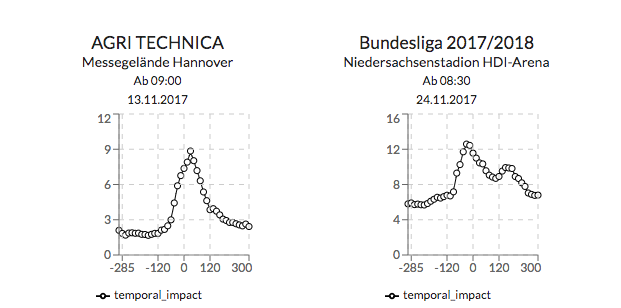
In addition, the graph at the top right gives additional information on how big the impact around the events start time tends to be.
{API}
We enriched the api endpoints with additional information from the data models that were developed as part of the research efforts.
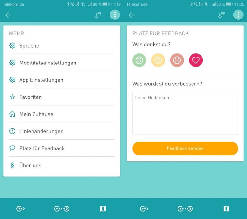
D4UM App Version 1.0
We just released the first Version of the D4UM App. Every project member now has access to the application and can try out its features. Let’s quickly go over some of its main features.
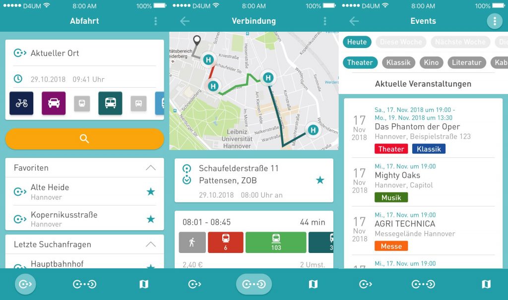
The EFA integration (EFA is a routing engine covering Lower Saxony and Bremen ) allows for quick access to tip information using all available public transport options. Our focus, when designing the application, was on quick and easy navigation to provide a simple and easy to use trip planning tool.
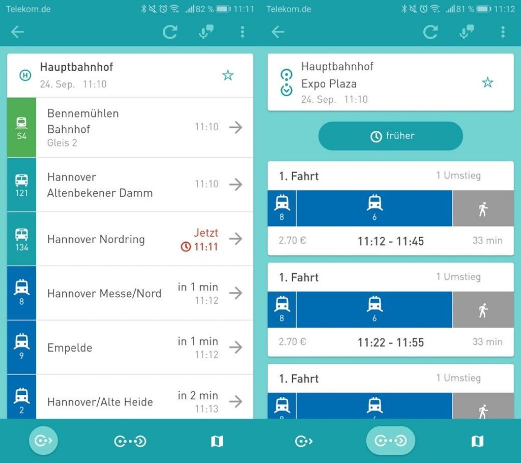
Departures and Connections
On the departure screen we show the user the closes stops for public transportation in his immediate vicinity. On the connection screen the user can fill in his desired starting location( either an address or an existing stop ) and destination and query for what connections are available to him. The provided information contains real time data , meaning we are able to visualized delays for any given connection.
Map
On the map screen you can see and or find all available stops of public transportation. This allows for providing the user with a great way to find out what stops are available in their city. By clicking on any of the shown stops will open the departure screen and provide you with the information mentioned above. To better visualize a selected connection, we show the route you plan to travel on the map.
Menu / Settings
Additional features can be found in the settings menu of the application. Here you can find settings that allow you to customize your routing results for both the departures and connection screen. The best way to let us know what you think about the application is to use the feedback module. This can be found here as well. First click on the emoji that best describe how you feel about the app. And then put in any additional information or ideas or thoughts you may have. Now what is left is just to press send and you will send us an email.
We look forward to hearing from you.
Quantification and Prediction of Impact of Public Events
Current Data4UrbanMobility research results allow for measuring and prediction of spatial impact on road traffic of public events. Connected, affected street segments nearby public events are identified to measure the spatial impact. The approach is depicted in the following figure:
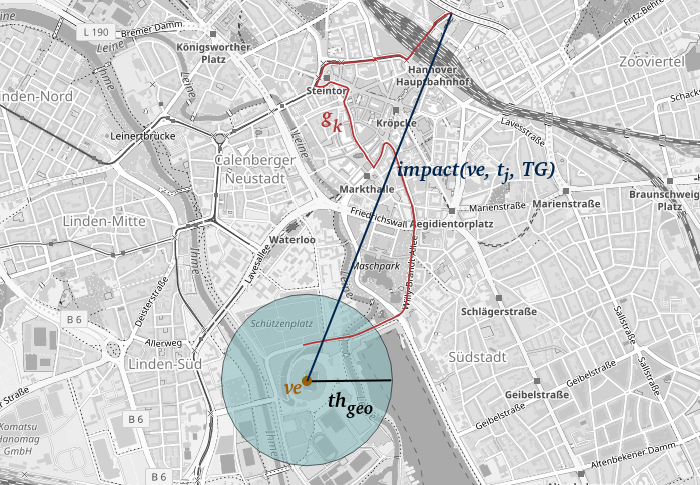
An event is marked as yellow dot, affected streets in red and the measured impact in dark blue. Moreover, an approach making use of machine learning algorithms was developed to predict the impact determined in this way, resulting an error-reduction of up to 40% when compared to existing state-of-the-art approaches.
D4UM – Platform V1 Released
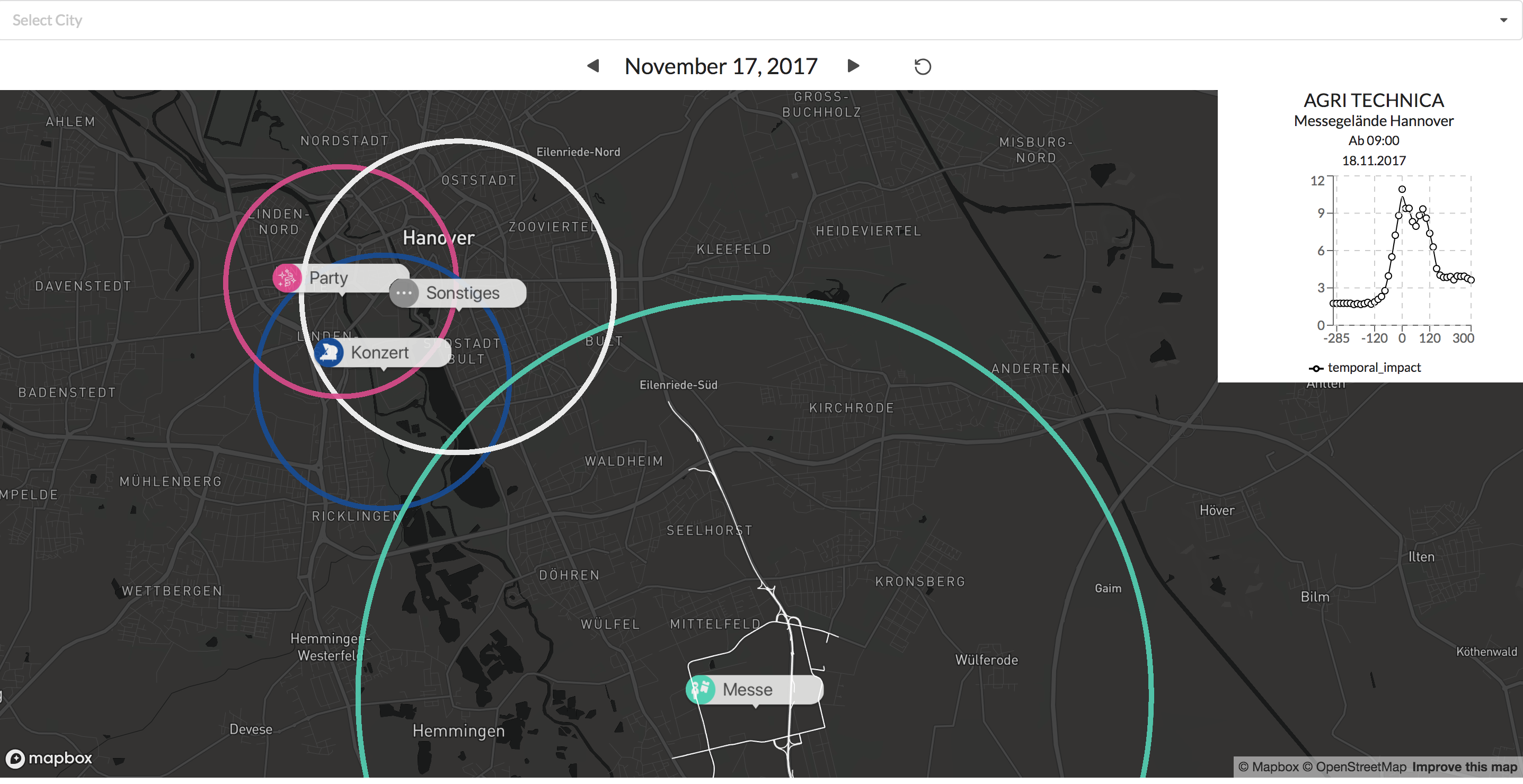
The first version of the Data4UrbanMobiltiy platform has been released. The platform was designed and implemented following a 3-tier-architecture. The platform provides RESTfull Web services for mobility applications like dashboards or mobile apps. As a demonstration, an interactive map application has been developed that visualizes the spatial impact of public events. The following figure shows a screenshot of the application.
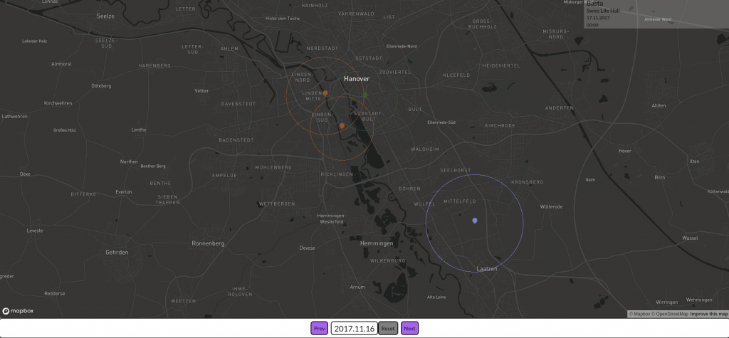
The figure shows 4 public events in the city of Hannover. The colors represent different types of public events (e.g. concerts, fairs, sport events). The circles visualize the spatial impact on road traffic caused by the public events.
Comprehensive Set of Requirements
The Data4UrbanMobility analysis of requirements includes requirements of the application partners Region Hannover (RH) and Wolfsburg AG (WAG) as well as non functional requirements. The requirements were collected by MOMA. The L3S derived research question for data analysis which are based on the requirements of RH and WAG. The research question address especially the information needs of end-users.
The current research questions particularly include
- Automated verification of traffic warnings and prediction of their impact
- Identification of events and prediction of their impact
- Investigation of correlation of road traffic data, public transportation query logs, traffic warnings and twitterfeeds
- Determination of optimal traveling timepoints
Growing Data Collection
ISU create a comprehensive data matrix containing potential source of mobility related data. The Data4UrbanMobility data model describes all project relevant data sets and sets them into context. This makes the data available in a unified manor for both analysis and applications. The selected data sources were transformed according to the Data4UrbanMobility data model by L3S. The data quality of selected data sources (i.e. public transportation query logs and road traffic data) was examined.
Tools for extracting the relevant information from the datasets were developed to enable the integration of the datasets.
- Street and graph extraction from OpenStreetMap
- Bulkloader for public transportation queries
- Integration of “Zentrales Haltestellen Verzeichniss” (central registry of public transportation stops)
The current collection (December 12th 2017) contians
EFA-Logs: 17 million public transportation queries
Road traffic data: 174 thousand street sements with a frequency of 15 minutes
GTFS-data: 90 thousand. public transportation stops, 2.6 thousand routes
Weather: Radolan “Regenraster” (rain grid)
Twitter: 2,5 Mio. Tweets starting at June 2017
OSM: 440 thousand streets
Events: 21 thousand public events (August 14th 2016-July 17th 2018)
Traffic warnings: 13 thousand warning (since June 2017)
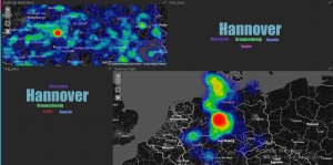
Visualization of Public Transportation Information
In order to allow intuitive analytics of public transportation information, the PROJEKTIONISTEN (PROJ) developed a dashboard web application. First prototypes visualize queries addressed to the regional timetable information system EFA (www.efa.de). The prototypes serve as foundations for exploration analyses as well as the implementation of future versions of the dashboard. The following figure shows an integrated visualization of the most frequent origins and destinations of the queries.
Analysen der EFA-Logs
Analysis of EFA Public Transportation Query Logs
Analyses regarding the impact of public events on public transportation are currently conducted to address early research questions. To this extend, explorative data analyses of the impact of major public events such as football games and medium sized events such as concerts were conducted. Visual analytics were used as a first step towards comprehensive analyses, which show start-like patterns for city center which identify mobility hubs of central importance.
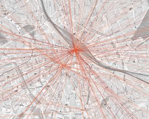
The figure shows the direct connection between origin and destination of public transportation queries. Darker colors correspond to more frequent queried trips. Star-like pattern identify the central train station and the central metro station.
Analyses of single stations reveal weekday dependent patterns.
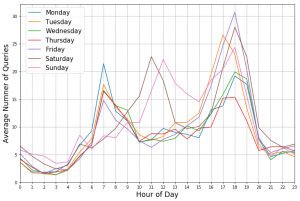
The figure depicts the average number of queries with the destination “Hannover Stadionbrücke”. Differences emerge between Weekends and workdays.
The impact of public events on the queries can be visualized as well.
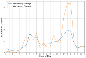
The figure shows the number of queries with the Destination “Hannover Stadionbrücke” for Wednesday, April 26th 2017 (orange) as well as the average number of queries on a Wednesday for the same destination. On this day a concert took place in venue nearby. The concert start at 8 pm. The significant deviations between 5 pm and 7 pm is highly likely to be caused by visitors of the concert. This shows that public transportation queries are a valuable information source to investigate the impact of public events on mobility infrastructure.
Next Generation Metrics for Scientific and Scholarly Research in Europe. Bosman, Jeroen; Debackere, Koenraad; Cawthorn, William; Galimberti, Paola; Graffner, Mikael; Held, Leonhard; Hermans, Karlijn; Killard, Fiona; Labastida, Ignasi; Millar, Andrew; Robinson, Mark; Roser, Kristell; Svendsen, Michael; Wouters, Paul (2024, May).
The field of evaluating academic activities is vast, complex, and highly dynamic, as are the roles of any data and indicators used to support these evaluations This Next Generation Metrics for Scientific and Scholarly Research in Europe paper, explores how universities can and should use currently available metrics and data to assess their research evaluation processes, in conjunction with qualitative expertise and information. The authors have chosen to focus on the aspect of academic evaluation that shows great potential for significant advancements in the coming years: the use and advancement of next-generation metrics for responsible research evaluation, encompassing open science, societal impact, and innovation. The paper aims to support universities in shaping their metric policies in alignment with their own missions, rather than relying solely on standard metrics and data availability. The paper furthermore intends to serve as a framework for universities to determine priorities to work on in specific domains for the application of contextually relevant indicators and metrics. The authors place strong emphasis on the reuse of existing expertise on metrics as well as on collaboration, both among universities and between universities and funding agencies to achieve these goals.
Best Mechanical product supplier in UAE rmsg (2024).
Application of Stone-Derived Substrates in Thin-Film Temperature Sensing. Khaanghah, Niloofar Saeedzadeh; Oliveira, Hugo de Souza; Krik, Soufiane; Carrasco-Pena, Alejandro; Cantarella, Giuseppe; Haller, Michael; Rapagnani, Nicholas; Van Bezooijen, Aart; Nippa, Michael; Münzenrieder, Niko (2024). 1–1.
Advancements in materials and technologies have enabled thin-film electronics to be directly developed on previously unsuitable substrates. This paper explores the fabrication of two thin-film temperature sensors, thermistors and resistance temperature detectors (RTD), using stone-based substrates, including marble, brick, stone paper, and Limex paper. The thermistors and RTDs were fabricated utilizing Cu / InGaZnO and Zn, applying the sputtering deposition technique. The sensor’s performance was analyzed based on two different heating methodologies: one using a hotplate, and the other using a localized heating from above. The sensors’ performance was characterized within a temperature range of 25 °C to 80 °C. While the marble thermistor demonstrated the highest sensitivity among all thermistors at -11.54%°C-1, the stone paper RTD similarly showed the highest sensitivity among all RTDs at 0.77 °C-1. The localized heating methodology on top of RTDs resulted in the stone paper and Limex showing negligible hysteresis. Moreover, the sensors demonstrated stable behavior in the multiple reliability tests. Furthermore, Zn-based RTDs were dissolvable in less than 36 hours. The outcomes show that stone-based materials are promising natural eco-friendly substrates for temperature sensors leading to less hazardous electronic waste.
Prostate-Specific Antigen Screening and 15-Year Prostate Cancer Mortality: A Secondary Analysis of the CAP Randomized Clinical Trial. Martin, Richard M.; Turner, Emma L.; Young, Grace J.; Metcalfe, Chris; Walsh, Eleanor I.; Lane, J. Athene; Sterne, Jonathan A. C.; Noble, Sian; Holding, Peter; Ben-Shlomo, Yoav; Williams, Naomi J.; Pashayan, Nora; Bui, Mai Ngoc; Albertsen, Peter C.; Seibert, Tyler M.; Zietman, Anthony L.; Oxley, Jon; Adolfsson, Jan; Mason, Malcolm D.; Davey Smith, George; Neal, David E.; Hamdy, Freddie C.; Donovan, Jenny L.; Oliver , Steven; Brindle , Peter ; Evans, Simon; Frankel, Stephen; Down, Liz; Tazewell, Marta; Shiarly, Pete; Thorn, Joanna; Harrison , Sean; Hounsome, Luke; Davies, Charlotte; Hughes, Laura; Rowlands, Mari-Anne; Bell, Lindsey; Hill, Elizabeth; Ng, Siaw Yein; Williams, Naomi; Toole, Jessica; Baum, Michael; Roberts, Tracy; Robinson, Mary; Dearnaley, David ; Schröder, Fritz; Peters, Tim; Lennon, Teresa; Bonnington, Sue; Holmberg, Lars; Pickard, Robert; Thompson, Simon; Menon, Usha; McFarlane, Jon; Bryant, Richard; Dormer, John; Reid, Colette; Bahl, Amit; Koupparis, Anthony; Gunnell, David (2024). 331(17) 1460.
Grundlagenwissen zu Künstlicher Intelligenz von angehenden Lehrkräften Schmidt, Jacqueline Marie-Charlotte (2024).
Extreme precipitation and temperature indices under future climate change in central Asia based on CORDEX-CORE. Rai, Praveen; Bangelesa, Freddy; Abel, Daniel; Ziegler, Katrin; Huang, Jingshui; Schaffhauser, Timo; Pollinger, Felix; Disse, Markus; Paeth, Heiko (2024).
Dormant dune fields and ameliorative moisture conditions in the West Gobi Desert in East Asia during the Last Interglacial. Zheng, Junge; Zhang, Deguo; Yang, Xiaoping; Lehmkuhl, Frank; Stauch, Georg (2024). 643 112170.
Arid and semiarid regions are environmentally vulnerable to global warming. Thus, studying their environmental history during warm periods (e.g., the Last Interglacial, LIG) is crucial for understanding their future changes too. The West Gobi Desert is a transitional zone influenced by the westerlies and the East Asian monsoon system. Therefore, the variation in atmospheric circulation profoundly affects its water vapor transport and landscape evolution. Due to the scarcity of continuous records, the moisture transport process remains ambiguous, which limits further research on paleolake evolution and aeolian activity. Here, we combine paleoclimate simulations from the Coupled Model Intercomparison Project 6 (CMIP6)-Paleoclimate Modeling Intercomparison Project 4 (PMIP4) and geological records to clarify the water vapor transport pathways and aeolian activity in the West Gobi Desert during the LIG, compared to the reference period (the piControl). Our results show that increased rainfall and meltwater were possible supplies for surface water during the LIG and were associated with enhanced East Asian summer monsoon and higher surface air temperatures. Concomitantly, weakening aeolian activity and dormant dune fields occurred in the West Gobi Desert, resulting from higher surface moisture content and weaker surface wind regimes associated with the weakening westerlies and East Asian winter monsoon. Notably, the limited weakening of aeolian activity that occurred in the LIG winter and spring was caused by weaker surface wind and deteriorating surface moisture conditions, while the significant dormancy of dune fields in the LIG summer and autumn was initiated by the combined effects of ameliorative surface moisture conditions and lower surface wind speed.
Evaluation is key: a survey on evaluation measures for synthetic time series. Stenger, Michael; Leppich, Robert; Foster, Ian; Kounev, Samuel; Bauer, André (2024). 11 66.
It’s not just a game: social networks, isolation and mental health in online gamers. Prochnow, Tyler; Patterson, Megan S. (2024). ahead-of-print(ahead-of-print)
Purpose Online gaming has emerged as a popular activity providing a social outlet for millions. However, implications of online game networks for mental health remain disputed. Concepts of bridging social capital and bonding social capital may help characterize protective factors within social networks. This study aims to examine the associations between social capital derived from online versus in-person networks and mental health indicators among gamers. Design/methodology/approach Online gamers (n = 301) completed an online survey assessing their social networks (both in-person and through online gaming) and mental health indicators (depressive symptoms, anxiety, social isolation, perceived social support). Social network analysis was used to analyze bridging (network size, effective size, heterogeneity, weak ties) and bonding (closeness, frequent contact, confiding, connection quality) social capital. Separate linear regression models evaluated associations between bridging and bonding social capital for both online and in-person networks and depressive symptoms, anxiety, social support and social isolation. Findings In-person network characteristics showed the strongest associations with mental health outcomes. Greater average closeness and frequent confiding in the in-person network predicted lower isolation and fewer depressive symptoms. More diverse relationship types also correlated with lower depression. For online networks, closeness and confiding ties associated only with less isolation and greater support, not depressive symptoms, or anxiety. Originality/value While online gaming networks provide some degree of social support, in-person social capital exhibited stronger associations with mental health. This reinforces the importance of face-to-face relationships for emotional well-being. Findings suggest helping gamers cultivate close bonds offline. However, online connections still matter and should not be discounted.
Welche Iptv Box Ist Die Beste. open, time (2024).
DoRA: Weight-Decomposed Low-Rank Adaptation. Liu, Shih-Yang; Wang, Chien-Yi; Yin, Hongxu; Molchanov, Pavlo; Wang, Yu-Chiang Frank; Cheng, Kwang-Ting; Chen, Min-Hung (2024).
Evaluation is key: a survey on evaluation measures for synthetic time series. Stenger, Michael; Leppich, Robert; Foster, Ian; Kounev, Samuel; Bauer, André (2024). 11 66.
ORPO: Monolithic Preference Optimization without Reference Model. Hong, Jiwoo; Lee, Noah; Thorne, James (2024).
Effects of improved land surface processes in the regional climate model REMO on climate means and extremes in Mainland Southeast Asia. Abel, Daniel; Ziegler, Katrin; Pollinger, Felix; Paeth, Heiko (2024).
A Comprehensive Guide to Choosing the Perfect Printer for Your Office. Admin (2024).
Rechtliche Zulässigkeit einer Verknüpfung staatlicher Zuwendungen mit sozialen Vorgaben Zenke, Ines; Heymann, Tigran; Arnold, Nelly; Zheng, Valentine (2024).
Öffentliche Gelder müssen im Sinne von Gemeinwohl und Guter Arbeit eingesetzt werden, fordert der DGB. Dass die öffentliche Hand auch das Recht hat, für finanzielle Zuschüsse Standort- und Tariftreue einzufordern, zeigt ein aktuelles juristisches Gutachten.
KI und algorithmische Systeme verstehen, bewerten und begrenzen. Technical Report (59), Grasy, Jonas; Seibold, Bettina; Klengel, Ernesto (2024).
Algorithmische Systeme und insbesondere künstliche Intelligenz (KI) sind zentrale Technologien moderner Digitalisierungsstrategien. Sie faszinieren und verunsichern gleichermaßen. In den Unternehmen kommen zunehmend KI-getriebene Systeme wie ChatGPT und Microsoft CoPilot zum Einsatz, die gewohnte Formen der Arbeit grundsätzlich verändern. Außerdem stellen sie die Mitbestimmung vor neue Herausforderungen: Betriebs- und Personalräte müssen sich jenseits der eingespielten IT-Mitbestimmung mit Anwendungsfällen und Einsatzbereichen von KI auseinandersetzen, um die Risiken für die Beschäftigten abschätzen und abmildern zu können Die Mitbestimmungspraxis zeigt Praxisbeispiele dafür, wie Betriebsräte mit neuen und bewährten Methoden das Thema KI und algorithmische Systeme angehen. Damit Letztere keine negativen Folgen für die Beschäftigten haben, müssen die Mitbestimmungsakteure die Anwendungen verstehen, bewerten und begrenzen können.
COVID-19 and Platform Work in Germany: Lessons for the New Normal. Herzog, Lorena; Cooiman, Franziska; Gerber, Christine; Wandjo, David (2024).
During the COVID-19 pandemic, when public life was largely brought to a standstill by lockdowns and curfews, the vast presence of last-mile-delivery workers rushing to deliver parcels, grocery shopping or take- away-meals on the streets of German cities came to the fore. Platform-based service provision has become widespread in recent years. The platform economy more than quadrupled in recent years, reaching a size of 14bn EUR in 2020, compared to just 3bn EUR in 2016 (European Council 2023). COVID-19 has created an exceptional situation, both for platforms and platform workers: Platform companies faced unstable economic conditions and government restrictions. Meanwhile, many platform workers, especially in the delivery and mobility sector, were exposed to significant health risks as they ensured the upholding of social reproduction throughout the pandemic. However, public attention for the perils of platform workers has quickly died down again. Today, the platform economy continues to provide sought-after services and constitutes a source of income for a growing number of workers struggling with precarious employment conditions. It is crucial to take stock of the effects of COVID-19 on the platform economy and its workers – both to gain an understanding of the new normal of platform work in the post-pandemic economy and to determine the political changes necessary to shape this new normal in favor of fair and decent working conditions and a resilient economy.
test publication record Stadnyk, Serhii (S. Stadnyk, ed.) (2024).
Unveiling Temporal Performance Deviation: Leveraging Clustering in Microservices Performance Analysis. Bauer, André; Dittus, Timo; Straesser, Martin; Kamatar, Alok; Baughman, Matt; Beierlieb, Lukas; Hadry, Marius; Grillmeyer, Daniel; Lubas, Yannik; Kounev, Samuel; Foster, Ian; Chard, Kyle in ICPE ’24 Companion (2024). 72–76.
As the market for cloud computing continues to grow, an increasing number of users are deploying applications as microservices. The shift introduces unique challenges in identifying and addressing performance issues, particularly within large and complex infrastructures. To address this challenge, we propose a methodology that unveils temporal performance deviations in microservices by clustering containers based on their performance characteristics at different time intervals. Showcasing our methodology on the Alibaba dataset, we found both stable and dynamic performance patterns, providing a valuable tool for enhancing overall performance and reliability in modern application landscapes.
Dune behavior in the Source Area of the Yellow River under climate changes observed from various remote sensing datasets. Dörwald, Lukas; Lehmkuhl, Frank; Delobel, Lucie; Zhang, Deguo; Yang, Xiaoping; Stauch, Georg (2024). 67-69 100928.
Sand dunes are a landscape feature with a quick response time to climate change and human influences (e.g. grazing, greening projects, and fixation structures). Their migration rates and their development can help to gather information about changing environmental conditions over time. The Source Area of the Yellow River (SAYR), located upon the Tibetan Plateau, is highly complex with topographical, hydrological, and climatological influences on active dunes, making it a good study area for these interactions. Based on remote sensing datasets, spanning the last 54 years, 415 dunes were mapped for migration rate calculations. Further, climate data from ERA-5 reanalysis and a local climate station was used to assess their changes within a changing climate. Generally, dune migration rates are rather slow with an average of 3.62 m y-1. In accordance, the averaged resultant drift potential (RDP) values are lower than 10 m3/s−3(−|-). Further, we assessed the density development of the main active barchan dune field in direct premise of the Yellow River. Throughout the past 54 years, we observed the emergence of more than 5 new barchans per square kilometer. This increase is likely attributed to higher sand flux from the Yellow River, which has resulted from increased discharge due to declining snowfall and rising precipitation levels.
Operazione Tokio - Podcast. Schenetti, Davide (2024).
Bias-free access to orbital angular momentum in two-dimensional quantum materials. Erhardt, Jonas; Schmitt, Cedric; Eck, Philipp; Schmitt, Matthias; Keßler, Philipp; Lee, Kyungchan; Kim, Timur; Cacho, Cephise; Cojocariu, Iulia; Baranowski, Daniel; Feyer, Vitaliy; Veyrat, Louis; Sangiovanni, Giorgio; Claessen, Ralph; Moser, Simon (2024). 132(19) 196401.
A universal and fully experimental algorithm allows for extraction of orbital angular momentum from 2D quantum materials.
Empirische Evaluation von personalisierten Fahrgastinformationen auf einem Smart Public Display. Wehr, F.; Beckers, L.; Schmidt, L. Gesellschaft für Arbeitswissenschaft e. V. (ed.) (2024). 1–6 (D.2.1).
In der hier vorgestellten Laborstudie wurde ein Smart Public Display mit personalisierten Fahrgastinformationen des öffentlichen Personennahverkehrs mit dem Stand der Technik, einem Public Display mit allgemeinen Fahrgastinformationen nahegelegener Haltestellen, verglichen. Unter Einbezug des Abstands einer umstehenden Person wurde die Technologieakzeptanz mit dem TUI-, die Gebrauchstauglichkeit mit dem SUS- und die Nutzererfahrung mit dem UEQ-Fragebogen erhoben. Die Ergebnisse zur Technologieakzeptanz zeigen keine signifikanten Unterschiede. Hinsichtlich der Gebrauchstauglichkeit und Nutzererfahrung deuten die Unterschiede darauf hin, dass Weiterentwicklungspotential, aber auch ein Mehrwert des Smart Public Displays mit personalisierten Fahrgastinforma-tionen gegenüber dem Public Display bestehen.
Social dialogue as a form of bottom-up governance for AI: the experience in France. Chagny, Odile; Blanc, Nicolas (2024). 197–205.
Protection of correlation-induced phase instabilities by exceptional susceptibilities. Reitner, M.; Crippa, L.; Fus, D. R.; Budich, J. C.; Toschi, A.; Sangiovanni, G. (2024). 6(2) L022031.
At thermal equilibrium, generalized susceptibilities encoding the static physical response of Hermitian many-electron systems are shown to possess inherent non-Hermitian matrix symmetries, leading to the generic occurrence of exceptional points. In strongly correlated electron systems, such exceptional points are found to necessarily promote electronic charge instabilities that occur in the proximity of a Mott transition to a topologically robust phenomenon.
Digitalisierung der Verwaltung in Deutschland: Zwischen Anspruch und Wirklichkeit Gräfe, Philipp; Wehmeier, Liz Marla; Bogumil, Jörg; Kuhlmann, Sabine in Modernisierung des öffentlichen Sektors (2024). (1. Auflage ) Nomos, Baden-Baden.
Deutschland kommt bei der Verwaltungsdigitalisierung, trotz Onlinezugangsgesetz und ambitionierter Digitalisierungsprogramme, nur langsam voran. Der Sonderband untersucht die Digitalisierungspraxis in den fortgeschrittenen Verwaltungsbereichen Kfz-Zulassung, Bauaufsicht, Steuerverwaltung und Elternleistungen. Detailliert werden Veränderungen von Organisation, Arbeitsprozessen und -bedingungen auf der Vollzugsebene analysiert und entscheidende Erfolgsfaktoren und Digitalisierungshemmnisse herausgearbeitet. Die Studie zeigt, dass die unterschiedlichen Verwaltungen oft mit ähnlichen, aber auch spezifischen Problemstellungen durch Digitalisierung konfrontiert sind. Anspruch und Wirklichkeit zwischen politischen Ankündigungen und realen Bedürfnissen in den lokalen Fachämtern klaffen noch weit auseinander.
Gibraltar subduction zone is invading the Atlantic. Duarte, João C.; Riel, Nicolas; Rosas, Filipe M.; Popov, Anton; Schuler, Christian; Kaus, Boris J.P. (2024). 52(5) 331–335.
Subduction initiation is a cornerstone of the Wilson cycle. It marks the turning point in an ocean's lifetime, allowing its lithosphere to be recycled into the mantle. However, formation of new subduction zones in Atlantic-type oceans is challenging, given that it commonly involves the action of an external force, such as the slab pull from a nearby subduction zone, a far-field compression, or the impact of a plume. Notwithstanding, the Atlantic already has two subduction zones, the Lesser Antilles and the Scotia arcs. These subduction zones have been forced from the nearby Pacific subduction zones. The Gibraltar arc is another place where a subduction zone is invading the Atlantic. This corresponds to a direct migration of a subduction zone that developed in the closing Mediterranean Basin. Nevertheless, few authors consider the Gibraltar subduction to be still active because it has significantly slowed down in the past millions of years. Here, we use new gravity-driven geodynamic models that reproduce the evolution of the Western Mediterranean, show how the Gibraltar arc formed, and test if it is still active. The results suggest that the arc will propagate further into the Atlantic after a period of quiescence. The models also show how a subduction zone starting in a closing ocean (Ligurian Ocean) can migrate into a new opening ocean (Atlantic) through a narrow oceanic corridor. Subduction invasion is likely a common mechanism of subduction initiation in Atlantic-type oceans and a fundamental process in the recent geological evolution of Earth.
Correlated evolution between body size and echolocation in bats (order Chiroptera). Castro, Mario G.; Amado, Talita Ferreira; Olalla-Tárraga, Miguel Á. (2024). 24(1) 44-.
Body size and echolocation call frequencies are related in bats. However, it is unclear if this allometry applies to the entire clade. Differences have been suggested between nasal and oral emitting bats, as well as between some taxonomic families. Additionally, the scaling of other echolocation parameters, such as bandwidth and call duration, needs further testing. Moreover, it would be also interesting to test whether changes in body size have been coupled with changes in these echolocation parameters throughout bat evolution. Here, we test the scaling of peak frequency, bandwidth, and call duration with body mass using phylogenetically informed analyses for 314 bat species. We specifically tested whether all these scaling patterns differ between nasal and oral emitting bats. Then, we applied recently developed Bayesian statistical techniques based on large-scale simulations to test for the existence of correlated evolution between body mass and echolocation.
Adaptive link dynamics drive online hate networks and their mainstream influence. Zheng, Minzhang; Sear, Richard F.; Illari, Lucia; Restrepo, Nicholas J.; Johnson, Neil F. (2024). 1(1) 2-.
Online hate is dynamic, adaptive— and may soon surge with new AI/GPT tools. Establishing how hate operates at scale is key to overcoming it. We provide insights that challenge existing policies. Rather than large social media platforms being the key drivers, waves of adaptive links across smaller platforms connect the hate user base over time, fortifying hate networks, bypassing mitigations, and extending their direct influence into the massive neighboring mainstream. Data indicates that hundreds of thousands of people globally, including children, have been exposed. We present governing equations derived from first principles and a tipping-point condition predicting future surges in content transmission. Using the U.S. Capitol attack and a 2023 mass shooting as case studies, our findings offer actionable insights and quantitative predictions down to the hourly scale. The efficacy of proposed mitigations can now be predicted using these equations.
In the land of the apu: Cerro Llamocca as a sacred mountain and central place in the pre-Columbian Andes of southern Peru. Mader, Christian; Reindel, Markus; Isla, Johny; Behl, Martin; Meister, Julia; Hölzl, Stefan (2023). 49 104045.
Anthropogenic influence of open pit mining on river floods, an example of the Blessem flood 2021. Lehmkuhl, Frank; Stauch, Georg (2023). 421 108522-.
Large scale anthropogenic relief changes result in a non-equilibrium landscape and such landscapes are prone to catastrophic erosion events during river floods. An example is the major flood event in western German in July 2021. During this event, the Erft River flooded an open gravel pit near the village of Erftstadt-Blessem, resulting in a massive erosional event, including the catastrophic destruction of parts of the settlement. Three different geomorphological periods occurred during the event: I) rapid backward erosion caused the destruction of the overlaying soils and floodplain sediments. Consequently, the gravel pit was filled with water and sediments. Three different pathways of backward erosion were activated during this period. II) Sedimentation in a temporary lake and the formation of alluvial fans. III) The Erft River moved towards the gravel pit due to the erosional processes followed by a second flood. Understanding of such complex erosional and depositional processes in open pit mining areas might serve as a blueprint for processes and hazards in anthropogenic influenced landscapes.
Automatic Evaluation of Attribution by Large Language Models. Yue, Xiang; Wang, Boshi; Chen, Ziru; Zhang, Kai; Su, Yu; Sun, Huan (2023).
A recent focus of large language model (LLM) development, as exemplified by generative search engines, is to incorporate external references to generate and support its claims. However, evaluating the attribution, i.e., verifying whether the generated statement is fully supported by the cited reference, remains an open problem. Although human evaluation is common practice, it is costly and time-consuming. In this paper, we investigate the automatic evaluation of attribution given by LLMs. We begin by defining different types of attribution errors, and then explore two approaches for automatic evaluation: prompting LLMs and fine-tuning smaller LMs. The fine-tuning data is repurposed from related tasks such as question answering, fact-checking, natural language inference, and summarization. We manually curate a set of test examples covering 12 domains from a generative search engine, New Bing. Our results on this curated test set and simulated examples from existing benchmarks highlight both promising signals and challenges. We hope our problem formulation, testbeds, and findings will help lay the foundation for future studies on this important problem.
Dune movement under climatic changes on the north-eastern Tibetan Plateau as recorded by long-term satellite observation versus ERA-5 reanalysis. Dörwald, Lukas; Lehmkuhl, Frank; Walk, Janek; Delobel, Lucie; Boemke, Bruno; Baas, Andreas; Zhang, Deguo; Yang, Xiaoping; Stauch, Georg (2023). 48(13) 2613–2629.
The movement of active dunes is tightly linked to climatic conditions (e.g., wind regime, temperature and precipitation) as well as human influence (e.g., grazing, dune fixation and greening). Dune migration rates can be studied to draw conclusions of changing wind conditions over time. The Gonghe Basin (GB), located on the north-eastern Tibetan Plateau (TP), offers a good testing ground for these assumptions. The intramontane basin is highly influenced by two major wind regimes: the mid-latitude Westerlies and the East Asian summer monsoon. To investigate environmental changes, this study combines optical remote sensing techniques with climatic datasets. High-resolution satellite images of the last five decades, such as CORONA KH-4B, are used to map dunes and calculate their respective migration rates. Further, height information was extracted as well. Climatic changes from the ERA-5 reanalysis dataset and normalized difference vegetation index (NDVI) values were processed alongside. Relating the dunes' surface processes to climate model data shows an accordance between slowing migration, expanding vegetation and a decrease in sand drift potential. From 1968 to present time, an average dune migration rate of 7.3 m a−1 was extracted from the satellite images, with an overall reduction of −1.81 m a−1. The resultant drift potential (RDP) values for the GB are calculated to be below 10 m3 s−3 with a spatial decrease, following a direction from the NW to the SE, fitting well with a corresponding decrease in the migration rates. Our results indicate a good agreement between the development of aeolian landforms and the ERA-5 climate reanalysis model data, even in a high-altitude setting with complex topography, which is known to influence such datasets.
Hochschuldidaktik als Wissenschaft Rüdiger Rhein, Johannes Wildt (Hg.) (2023).
Projected changes in rainfall amount and distribution in the Democratic Republic of Congo ? Evidence from an ensemble of high-resolution climate simulations. Bangelesa, F.; Abel, D.; Pollinger, F.; Rai, P.; Ziegler, K.; Ebengo, D.; Tshimanga, R.M.; Mala Ali, M.; Knight, J.; Paeth, H. (2023). 42
Optimization-Aware Compiler-Level Event Profiling. Basso, Matteo; Prokopec, Aleksandar; Rosà, Andrea; Binder, Walter (2023). 45(2)
Tracking specific events in a program’s execution, such as object allocation or lock acquisition, is at the heart of dynamic analysis. Despite the apparent simplicity of this task, quantifying these events is challenging due to the presence of compiler optimizations. Profiling perturbs the optimizations that the compiler would normally do—a profiled program usually behaves differently than the original one.In this article, we propose a novel technique for quantifying compiler-internal events in the optimized code, reducing the profiling perturbation on compiler optimizations. Our technique achieves this by instrumenting the program from within the compiler, and by delaying the instrumentation until the point in the compilation pipeline after which no subsequent optimizations can remove the events. We propose two different implementation strategies of our technique based on path-profiling, and a modification to the standard path-profiling algorithm that facilitates the use of the proposed strategies in a modern just-in-time (JIT) compiler. We use our technique to analyze the behaviour of the optimizations in Graal, a state-of-the-art compiler for the Java Virtual Machine, identifying the reasons behind a performance improvement of a specific optimization, and the causes behind an unexpected slowdown of another. Finally, our evaluation results show that the two proposed implementations result in a significantly lower execution-time overhead w.r.t. a naive implementation.
Statistical-dynamical modeling of the maize yield response to future climate change in West, East and Central Africa using the regional climate model REMO. Bangelesa, F.; Pollinger, F.; Sponholz, B.; Mapatano, M.A.; Hatl?y, A.; Paeth, H. (2023). 905
Climate change information tailored to the agricultural sector in Central Europe, exemplified on the region of Lower Franconia. Paeth, H.; Schönbein, D.; Keupp, L.; Abel, D.; Bangelesa, F.; Baumann, M.; Büdel, C.; Hartmann, C.; Kneisel, C.; Kobs, K.; Krause, J.; Krech, M.; Pollinger, F.; Schäfer, C.; Steininger, M.; Terhorst, B.; Ullmann, T.; Wilde, M.; Ziegler, K.; Zimanowski, B.; Baumhauer, R.; Hotho, A. (2023). 176(10)
Effect of an irrigation scheme implemented in a regional climate model over Central Asia. Rai, Praveen; Abel, Daniel; Ziegler, Katrin; Pollinger, Felix; Paeth, Heiko (2023).
Beispiele für morphodynamische Prozesse und Verlagerungen in Folge des Hochflutereignisses 2021 im Ahrtal. Lehmkuhl, Frank; Keßels, Johannes; Schulte, Philipp; Stauch, Georg; Dörwald, Lukas; Wolf, Stefanie; Brüll, Catrina; Schüttrumpf, Holger (2022). 24(11) 40–47.
Correction to: Performance of a regional climate model with interactive vegetation (REMO-iMOVE) over Central Asia (Theoretical and Applied Climatology, (2022), 150, 3-4, (1385-1405), 10.1007/s00704-022-04233-y). Rai, P.; Ziegler, K.; Abel, D.; Pollinger, F.; Paeth, H. (2022). 150(3-4) 1407.
Performance of a regional climate model with interactive vegetation (REMO-iMOVE) over Central Asia. Rai, P.; Ziegler, K.; Abel, D.; Pollinger, F.; Paeth, H. (2022). 150(3-4) 1385–1405.
Weathering under coastal hyperaridity – Late Quaternary development of spectral, textural, and gravelometric alluvial fan surface characteristics. Walk, Janek; Bartz, Melanie; Stauch, Georg; Binnie, Ariane; Brückner, Helmut; Lehmkuhl, Frank (2022). 277 107339-.
Hyperarid coasts develop under relatively high air humidity and abundant sea salt aerosols, resulting in physical and chemical weathering processes that distinctly differ from those present in inland deserts. However, neither the geomorphic effects of the weathering processes nor the timescales on which they alter depositional surfaces are sufficiently understood. In this study we therefore integrate spectral, textural, and gravelometric analyses based on high to very high resolution satellite and aerial remote sensing to assess the degree of post-depositional alteration of a multi-stage alluvial fan at the coast of the Atacama Desert. To further deduce the present-day as well as past intensities of responsible weathering processes we establish a morphochronology of the fan's evolution using cosmogenic 10Be exposure dating. Spectral, textural, and gravelometric parameters relatively date a succession of fan generations, assuming the weathering of fan surface sediments prior to deposition can be largely excluded. Under coastal hyperaridity, effects on the spectral surface signatures are primarily explained by the development of weathering rinds and related formation of secondary iron oxides. Spectral iron oxide ratios show little to no change during the Holocene but strongly increase during the Late Glacial, while over longer timescales an asymptotic increase is suggested. Clast breakdown can largely be attributed to salt weathering causing sublinear to roughly linear decreases in mean size, coarseness, and size variation of coarse clasts. Governed by clast breakdown as well as lateral remobilization of clasts, nano-scale surface roughness exhibits a non-monotonic, peak-shaped relationship with age, whereas the micro-relief experiences continuous smoothing due to denudation. Findings are summarized in a conceptual model showing that in hyperarid coastal environments fan surface weathering results over timescales of 104 to 105 a in a fully developed desert pavement. Two hypothetical scenarios are introduced which differ based on whether desert pavements remain stable over timescales exceeding the Late Pleistocene or not. Late Quaternary weathering intensity along the coast of the Atacama Desert is found to be related to sea surface temperature variability and sea level jointly driving the oceanic moisture supply.
Assessment of REgional MOdel REMO and its coupled version REMO-iMOVE over Central Asia. Rai, Praveen; Ziegler, Katrin; Abel, Daniel; Pollinger, Felix; Paeth, Heiko (2022).
Smartphone-supported mapping of landforms – A new tool in teaching geomorphology. Stauch, Georg (2022). 76(3) 227–234.
Understanding 3D properties of objects is an integral part of geomorphological teaching. This can best be achieved during field trips. However, there are numerous reasons why teaching outdoor might not be possible, either for a group of students or just individuals. 3D models of landforms, either static or interactive, are a great method to improve students learning success, e.g. in a blended learning environment. Preparation of 3D models of individual geomorphological landforms has been so far time-consuming. But since 2020, LiDAR sensors have been integrated into some new smartphones. These systems offer great potential for geomorphological teaching, as they enable simple and cost-effective recording of geomorphological landforms and objects in three dimensions. The smartphone LiDAR systems are suitable for the documentation and 3D reconstruction of objects in the range of several decimetres to metres. By means of three examples, the possible applications of smartphone-based LiDAR systems in the field of geomorphological teaching will be demonstrated. All in all, these smartphone LiDAR systems offer great potential, as they support the understanding of the three-dimensional structure of geomorphological landforms and objects in teaching in schools and universities and thus increase the success of teaching among pupils and students. Furthermore, 3D models make geomorphology more inclusive, e.g. for people not able to conduct field work. At the same time, in research, they offer new opportunities for scientific observation projects, e.g. through the continuous monitoring of geomorphological changes in the context of Citizen Science projects.
Comparison of different infiltration schemes in the regional climate model REMO. Abel, Daniel; Ziegler, Katrin; Pollinger, Felix; Paeth, Heiko (2021).
Different approaches of finding European climate analogue regions for the Steigerwald forest (Germany) in the future. Ziegler, Katrin; Pohl, Felix; Pollinger, Felix; Paeth, Heiko (2021).
Why analysing microplastics in floodplains matters: application in a sedimentary context. Lechthaler, Simone; Esser, Verena; Schüttrumpf, Holger; Stauch, Georg (2021). 23(1) 117–131.
Microplastics in the environment are a relatively new form of anthropogenic contamination. Right now, the research focus is on the detection of microplastic accumulation in different environmental compartments and understanding the processes that have led to its transport. Detailed information on microplastics in floodplain areas and their distribution in depth are still missing to better understand accumulation points. Therefore, this study presents on the one hand microplastic detection in fluvial sediments from nine sampling sites along a river course. Polymers were determined with infrared spectroscopy and additional sedimentary analysis of the grain size and heavy metal concentration was performed. In total, there was less microplastic in the upper than in the lower river course and slip-off slopes were identified as accumulation hotspots also in deeper sediment layers. Mostly, microplastic particles were detected in fine sediment and heavy metal concentrations along the river were similar to those of microplastics. On the other hand, besides the spatial distribution of microplastics and accumulation in floodplain areas, microplastic analysis offered information in a sedimentary context. Sedimentation rates (0.29–4.00 cm a−1) and patterns between temporal deposition and microplastic polymers were identified. The basis for the development of a dating method by detection of MPs in sediments was thus established. Microplastics as a contaminant provide, in addition to the identification of deposition areas, further data in a temporal and sedimentary perspective.
Relationship between soil sealing and local to regional climate in Germany. Kirchner, A.; Schmitt, M.; Pollinger, F.; Thiel, M.; Paeth, H. (2021). 30(5) 381–390.
The Way of Macroplastic through the Environment. Lechthaler, Simone; Waldschläger, Kryss; Stauch, Georg; Schüttrumpf, Holger (2020). 7(10) 73-.
With the focus on microplastic in current research, macroplastic is often not further considered. Thus, this review paper is the first to analyse the entry paths, accumulation zones, and sinks of macroplastic in the aquatic, terrestrial, and atmospheric environment by presenting transport paths and concentrations in the environment as well as related risks. This is done by applying the Source–Pathway–Receptor model on macroplastic in the environment. Based on this model, the life cycle of macroplastic is structurally described, and knowledge gaps are identified. Hence, current research aspects on macroplastic as well as a sound delimitation between macro- and microplastic that can be applied to future research are indicated. The results can be used as basic information for further research and show a qualitative assessment of the impact of macroplastic that ends up in the environment and accumulates there. Furthermore, the applied model allows for the first time a quantitative and structured approach to macroplastic in the environment.
Surface Roughness Estimation in the Orog Nuur Basin (Southern Mongolia) Using Sentinel-1 SAR Time Series and Ground-Based Photogrammetry. Ullmann, Tobias; Stauch, Georg (2020). 12(19) 3200-.
This study demonstrates an application-oriented approach to estimate area-wide surface roughness from Sentinel-1 time series in the semi-arid environment of the Orog Nuur Basin (southern Mongolia) to support recent geomorphological mapping efforts. The relation of selected mono- and multi-temporal SAR features and roughness is investigated by using an empirical multi-model approach and selected 1D and 2D surface roughness indices. These indices were obtained from 48 high-resolution ground-based photogrammetric digital elevation models, which were acquired during a single field campaign. The analysis is backed by a time series analysis, comparing Sentinel-1 features to temporal-corresponding observations and reanalysis datasets on soil moisture conditions, land surface temperature, occurrence of precipitation events, and presence and development of vegetation. Results show that Sentinel-1 features are hardly sensitive to the changing surface conditions over none to sparsely vegetated land, indicating very dry conditions throughout the year. Consequently, surface roughness is the dominating factor altering SAR intensity. The best correlation is found for the combined surface roughness index Z-Value (ratio between the root mean square height and the correlation length) and the mean summer VH intensity with an r2 coefficient of 0.83 and an Root-Mean-Square Error of 0.032.
Changes in mean flow and atmospheric wave activity in the North Atlantic sector. Heiko Paeth, Felix Pollinger (2020). Online-Ressource.
Testing the potential of K-feldspar pIR-IRSL and quartz ESR for dating coastal alluvial fan complexes in arid environments. Bartz, Melanie; Duval, Mathieu; Brill, Dominik; Zander, Anja; King, Georgina E.; Rhein, Alexander; Walk, Janek; Stauch, Georg; Lehmkuhl, Frank; Brückner, Helmut (2020). 556 124–143.
Coastal alluvial fans (CAF) are important geo-archives due to their sensitivity to both tectonic activity and climatic changes. Thus, they can give key insights for geomorphic and sedimentary processes. In this study we test the potential of K-feldspar post infrared-infrared stimulated luminescence (pIR-IRSL) and quartz electron spin resonance (ESR) methods for dating alluvial fan complexes in arid environments. The existing chronological data from marine terraces that interact with CAF make the Atacama Desert in northern Chile an excellent setting for this research. Samples have been collected from alluvial, marine and aeolian sediments embedded in the CAF complexes, allowing evaluation of the different signal properties and bleaching characteristics of the pIR-IRSL and ESR signals over Late Pleistocene time scales. pIR-IRSL dose distributions of clast-rich alluvial fan samples are characterised by higher scatter and demonstrate heterogeneous bleaching, while matrix-rich alluvial fan deposits show rather homogeneous poor bleaching in the dose dispersion as indicated by a modern analogue sample. In contrast, marine and aeolian deposits are homogeneously well bleached, supported by a modern littoral sample. Following the quartz multiple centre (MC) ESR dating approach (Al and Ti centres), bleaching of the different centres prior to deposition has been achieved. While the Ti–H centre provides mostly lower doses than the Ti–Li centre, in most cases the Al centre provides the highest dose values. This pattern is consistent with their respective bleaching kinetics and suggests that the Ti centre signals most likely provide the closest estimate to the true burial dose for samples with doses >200 Gy. ESR and pIR-IRSL ages are consistent at 2σ for the marine, aeolian and clast-rich debris-flow deposits, which is in agreement with existing chronological data in this area. It appears that the mode of sediment transport on alluvial fans, either as matrix- or clast-rich flows, plays an important role in sediment bleaching. While clast-rich alluvial fan deposits are likely better bleached, we cannot exclude insufficient bleaching during matrix-rich alluvial fan flows; our dating results suggest that both pIR-IRSL and ESR dating overestimate the true burial age. The combination of pIR-IRSL and MC ESR dating can be considered as a promising tool for deciphering alluvial fan formation over (Late) Pleistocene time scales.
Late Pleistocene alluvial fan evolution along the coastal Atacama Desert (N Chile). Bartz, Melanie; Walk, Janek; Binnie, Steven A.; Brill, Dominik; Stauch, Georg; Lehmkuhl, Frank; Hoffmeister, Dirk; Brückner, Helmut (2020). 190 103091-.
Due to their sensitivity to both tectonic activity and climatic variations, coastal alluvial fans (CAF) along the western flank of the Coastal Cordillera in the Atacama Desert (northern Chile) are important geo-archives for unravelling Quaternary environmental change. Our study focuses on terrestrial and marine deposits of five CAF complexes between 20° and 25°S along the coastal zone of the Atacama to identify phases of alluvial fan activity during the Late Quaternary. Based on a combination of luminescence dating and 10Be cosmogenic nuclide exposure dating as well as existing chronological data in the area, insights into climatic variations along the hyper-arid coast are presented for the Late Pleistocene derived from CAF morphodynamics. Activity of alluvial fans could be documented during time spans 95–80 ka, 60–45 ka, 35–20 ka, as well as the Holocene. Numerical dating of marine terrace deposits gives insights into the tectonic uplift of the Coastal Plain in northern Chile during the Late Quaternary period, for which estimated uplift rates between ~0.06 and ~0.57 m/ka were derived. While tectonic activity induces base-level changes, long-term tectonic activity rather indirectly controls alluvial fan activity. We suggest that alluvial fan activity is mainly controlled by atmospheric changes from the Pacific Ocean. Based on our observations, CAF in the hyper-arid Atacama Desert serve as suitable geo-archives for reconstructing climate changes during the Quaternary. In particular, the usefulness of alluvial fan systems in a water-limited environment is important for understanding the palaeoenvironmental evolution in a coastal desert.
Canola Oil Extraction in Conjunction with a Plastic Free Separation Unit Optimises Microplastics Monitoring in Water and Sediment. Lechthaler, Simone; Hildebrandt, Lars; Stauch, Georg; Schüttrumpf, Holger (2020).
Microplastics are widely distributed in the environment and to define contamination hot spots, environmental samples have to be analysed by means of cost- as well as time-efficient and reliable standardised protocols. Due to the lipophilic characteristics of plastic, oil extraction as a fast and density-independent separation is beneficial for the crucial extraction step. It was extensively validated (480 experiments) in two test setups by using canola oil and a cost-effective, plastic-free separation unit with spiked microplastic (19 different polymer types) in the density range from ρ = 11 - 1,760 kg/m³ and in the size range from 0.02 mm - 4.4 mm. Thus, an innovative, new method combination was developed and profoundly validated for water and sediment samples using only a short settling time of 15 minutes. Some experiments were also carried out with zinc chloride to obtain additional reference data (particles ≤ 359 µm). The total mean recovery rate was 89.3%, 91.7% within the larger microplastic fraction and 85.7% for the small fraction. Compared to zinc chloride (87.6%), recovery rates differed not significantly with oil (87.1%). Furthermore, size limits were set, since the method works best with particles 0.02 mm ≥ d ≤ 3 mm. The proposed method exhibits higher efficiency (84.8% for 20 - 63 µm) for the potentially most harmful microplastic size fraction than the classic setup using brine solution. As a result, oil is a comparably effective separation medium and offers further advantages for separating water and sediment samples due to its density independence, simple and fast application and environmental friendliness. Based on this, a new extraction protocol is presented here that confirms oil separation as a sound and effective separation in microplastic analysis and identifies previously missing information.
Gradients in climate, geology, and topography affecting coastal alluvial fan morphodynamics in hyperarid regions – The Atacama perspective. Walk, Janek; Stauch, Georg; Reyers, Mark; Vásquez, Paulina; Sepúlveda, Fernando A.; Bartz, Melanie; Hoffmeister, Dirk; Brückner, Helmut; Lehmkuhl, Frank (2020). 185 102994-.
Along the coast of the hyperarid Atacama Desert, late Quaternary alluvial fans emerge from the Coastal Cordillera to the Pacific Ocean between 20.5°S and 25.5°S. Coastal alluvial fans (CAF) show, in comparison to the interior fans of the Atacama Desert, pronounced recent activity. However, the complex interplay between climate, lithology, and tectonics affecting the CAF morphodynamics in such hyperarid coastal settings needs to be better understood. We therefore aim at assessing the major factors driving CAF activity and evaluate their effects along gradients. We conducted an extensive study relating climatic, lithologic, and tectonic characteristics to fan and catchment geomorphology of 123 CAF. Geomorphometric analyses are based on the 12.5 m TanDEM-X WorldDEM™, catchment lithology and faults are extracted from 13 regional geological maps, and the frequency of heavy rainfall events capable of activating CAF is derived from a Weather Research and Forecasting (WRF) regional climate model. Our results point to a primary climatic control on CAF morphodynamics shown in functional relationships with catchment hydromorphometric characteristics reflecting a high susceptibility to debris flows – the main CAF-constructing process. Catchment properties along the latitudinal gradient reflect the source of significant precipitation events: frontal systems and cut-off lows which mainly originate in the extratropics and become increasingly rare towards the north. The frequency of precipitation extremes can only be correlated to the hydromorphometry and geomorphic maturity of catchments that feature a high degree of sediment transport potential and generally do not cut back far into the Coastal Cordillera. Related to the strongly reduced influence of the Pacific precipitation source towards the east, this additional climatic transition is governed by the orographic effect of the steep W-E gradient in topography. In contrast, source-area lithology is of negligible relevance for CAF catchment morphometry and fan activity. An important indirect influence of tectonics, however, can be seen in the long-term (neo)tectonic activity within the Coastal Cordillera, which in turn shapes catchments and controls the topography.
BigData@Geo: A Climate Atlas for Lower Franconia (Germany). Schönbein, Daniel; Keupp, Luzia; Pollinger, Felix; Paeth, Heiko (2020).
Effects of a new land surface parametrization scheme on thermal extremes in a Regional Climate Model. Pollinger, Felix; Ziegler, Katrin; Abel, Daniel; Paeth, Heiko (2020).
Statistical modeling of phenology in Bavaria based on past and future meteorological information. Ziegler, K.; Pollinger, F.; Böll, S.; Paeth, H. (2020). 140(3-4) 1467–1481.
Oil Extraction as Separation Method for Microplastic in Sediment Samples. Lechthaler, Simone; Stauch, Georg; Schüttrumpf, Holger M. Cocca, E. Di Pace, M. E. Errico, G. Gentile, A. Montarsolo, R. Mossotti, M. Avella (eds.) (2020). 282–286.
Microplastic (MP), plastic particles smaller than 5 mm [1], is widely distributed in the environment [2] and has not only been detected in the aquatic environment [3] but also in terrestrial areas [4]. To understand the whole life cycle of MP it is important to analyse samples from different areas. With the detection of MP in different environmental compartments, it is possible to define sources, entry and transport paths and temporary and ultimate sinks of MP.
Regional study of microplastics in surface waters and deep sea sediments south of the Algarve Coast. Lechthaler, Simone; Schwarzbauer, Jan; Reicherter, Klaus; Stauch, Georg; Schüttrumpf, Holger (2020). 40 101488-.
Various studies show a contamination of the marine environment with microplastics due to the material persistence and a resulting accumulation. Right now, the environmental impact of microplastics is not fully determined and in order to obtain further information on contaminated areas, water surface samples and (deep sea) sediment from the Atlantic Ocean south of Algarve Coast (Portugal) were taken and analysed. Microfibres, 3 black fibres, were visually detected in 2 of the 20 sediment samples without verifying their polymeric identity. Assuming that they are microplastics, concentration from 0.00–0.29 particles/g dry sediment result. In the eleven water samples, 81.8% contained microplastics including polymeric identification (0.00–14.09 particles/m3) with an average contamination of 1.36 ± 4.03 particles/m3. A significant positive correlation between the microplastic concentration in the water and the average water depth during sampling was identified. This regional study is one of a few that analysed also deep sea sediment and provides results about microplastics as anthropogenic contaminants south of the Algarve coast.
Extension of the regional climate model REMO by a 5-layer soil scheme. Abel, Daniel; Pollinger, Felix; Ziegler, Katrin; Paeth, Heiko (2020).
Impact of climate change and variability on maize yield in Tropical Africa. Bangelesa, Freddy; Pollinger, Felix; Paeth, Heiko (2020).
REMOLAND: New high-resolution surface boundary data for the regional climate model REMO and their impacts. Ziegler, Katrin; Pollinger, Felix; Abel, Daniel; Paeth, Heiko (2020).
Comparing the lasso predictor-selection and regression method with classical approaches of precipitation bias adjustment in decadal climate predictions. LI, J.; POLLINGER, F.; PAETH, H. (2020). 148(10) 4339–4351.
Revisiting the spatiotemporal characteristics of past and future global warming. Paeth, H.; Pollinger, F. (2020). 74(4) 225–247.
Changes in mean flow and atmospheric wave activity in the North Atlantic sector. Paeth, Heiko; Pollinger, Felix (2019).
Weighted multi-model ensemble projection of extreme precipitation in the Mediterranean region using statistical downscaling. Keupp, Luzia; Hertig, Elke; Kaspar-Ott, Irena; Pollinger, Felix; Ring, Christoph; Paeth, Heiko; Jacobeit, Jucundus (2019).
Comparison of climate change from Cenozoic surface uplift and glacial-interglacial episodes in the Himalaya-Tibet region: Insights from a regional climate model and proxy data. Paeth, Heiko; Steger, Christian; Li, Jingmin; Pollinger, Felix; Mutz, Sebastian G.; Ehlers, Todd A. (2019). 177 10–26.
Geomorphology of the coastal alluvial fan complex Guanillos, northern Chile. Walk, Janek; Stauch, Georg; Bartz, Melanie; Brückner, Helmut; Lehmkuhl, Frank (2019). 15(2) 436–447.
The evolution of alluvial fans on the narrow coastal plain of the Atacama Desert in northern Chile is so far poorly investigated. Therefore, a detailed geomorphological map at a scale of 1:7500 of a coastal alluvial fan complex at Guanillos (21°58?S, 70°10.5?W) is provided as a first step to understand the fan?s morphogenesis. Geomorphological mapping was based on a digital elevation model with a resolution of 2?m generated from Pleiades-1 tri-stereo satellite imagery, derived terrain parameters, and on-site field mapping. The resultant map is used to characterize and categorize the overall morphology of the alluvial fan complex. In particular, linear features constructed by primary alluvial fan processes can be differentiated successfully from those developed by secondary processes. Furthermore, the advanced evolutionary state of the fan complex is revealed. We introduce a morphostratigraphic model comprising the fan?s prograde evolution, dissection, and successive abandonment of surface generations.
An effective drift correction for dynamical downscaling of decadal global climate predictions. Pollinger, Felix; Paeth, H.; Li, J.; Pollinger, F.; Müller, W.; Pohlmann, H.; Feldmann, H.; Panitz, H. (2019).
Bias adjustment for decadal predictions of precipitation in Europe from CCLM. Li, Jingmin; Pollinger, Felix; Panitz, Hans-Juergen; Feldmann, Hendrik; Paeth, Heiko (2019). 53(3–4) 1323–1340.
Weights for general circulation models from CMIP3/CMIP5 in a statistical downscaling framework and the impact on future Mediterranean precipitation. Kaspar‐Ott, Irena; Hertig, Elke; Kaspar, Severin; Pollinger, Felix; Ring, Christoph; Paeth, Heiko; Jacobeit, Jucundus (2019). 39(8) 3639–3654.
Effect of diversified performance metrics and climate model weighting on global and regional trend patterns of precipitation and temperature. Ring, C.; Pollinger, F.; Keupp, L.; Paeth, H.; Kaspar-Ott, I.; Hertig, E.; Jacobeit, J. (2019). 73(4) 303–322.
An effective drift correction for dynamical downscaling of decadal global climate predictions. Paeth, Heiko; Li, Jingmin; Pollinger, Felix; Müller, Wolfgang A.; Pohlmann, Holger; Feldmann, Hendrik; Panitz, Hans-Jürgen (2018). 52(3–4) 1343–1357.
Impacts of Climate Change in Central Asia. Mannig, B.; Pollinger, F.; Gafurov, A.; Vorogushyn, S.; Unger-Shayesteh, K. (2018). 195–203.
Influence of snow water equivalent on droughts and their prediction in the USA. Abel, Daniel; Pollinger, Felix; Paeth, Heiko (2018).
Dynamical-statistical projections of the climate change impact on agricultural production in Benin by means of a cross-validated linear model combined with Bayesian statistics. Awoye, O.H.R.; Pollinger, F.; Agbossou, E.K.; Paeth, H. (2017). 234-235 80–94.
Nước hoa chiết tphcm Yupi Perfume Perfume, Yupi (2017).
An efficient model approach for very high resolution orographic precipitation. Paeth, Heiko; Pollinger, Felix; Mächel, Hermann; Figura, Clarissa; Wahl, Sabrina; Ohlwein, Christian; Hense, Andreas (2017). 143(706) 2221–2234.
Comparison of the performance of three types of multiple regression for phenology in Bavaria in a dynamical-statistical model approach. Pollinger, Felix; Ziegler, Katrin; Paeth, Heiko (2017). 71(4) 271–285.
A comparison of metrics for assessing state-of-the-art climate models and implications for probabilistic projections of climate change. Ring, Christoph; Pollinger, Felix; Kaspar-Ott, Irena; Hertig, Elke; Jacobeit, Jucundus; Paeth, Heiko (2017). 50(5–6) 2087–2106.
Impacts of climate change in central Asia. Mannig, B.; Pollinger, F.; Gafurov, A.; Vorogushyn, S.; Unger-Shayesteh, K. (2017). 1-5 195–203.
Detection and Attribution of Multivariate Climate Change Signals Using Discriminant Analysis and Bayesian Theorem. Paeth, Heiko; Pollinger, Felix; Ring, Christoph (2017). 30(19) 7757–7776.
Assessment of future ENSO changes in a CMIP3/CMIP5 multi-model and multi-index framework. Keupp, Luzia; Pollinger, Felix; Paeth, Heiko (2016). 37(8) 3439–3451.
Bias correction of CCLM simulated temperature and precipitation in Europe using cross validated model output statistics. Pollinger, Felix; Li, Jingmin; Paeth, Heiko; Pollinger, Felix; Panitz, Hans-Juergen (2016).
Late Quaternary aeolian sand deposition sustained by fluvial reworking and sediment supply in the Hexi Corridor — An example from northern Chinese drylands. Nottebaum, Veit; Lehmkuhl, Frank; Stauch, Georg; Lu, Huayu; Yi, Shuangwen (2015). 250 113–127.
Aeolian deposits are frequently used for palaeoenvironmental change studies. Their formation depends on an array of requirements: the supply of material suitable for aeolian transport and favorable conditions of sediment availability and wind strength. In order to infer palaeoenvironmental information from aeolian sand deposits these factors need to be carefully evaluated. We present a study from northern Chinese Hexi Corridor, based on 11 optically stimulated luminescence (OSL) dated sediment sections. These represent interchanging aeolian and alluvial deposits under gravel surfaces and aeolian sand in dune fields interrupted by interdunal flood deposits. Investigations in two subareas reveal contrasting geomorphologic and sedimentary histories: (1) sediment deposition during the Pleistocene–Holocene transition (~12ka) followed by deflation during the Holocene and (2) frequent sediment recycling revealed by a wide spectrum of ages throughout the Holocene. The late glacial sediment pulse recorded in the western Hexi Corridor is attributed to high sediment supply, generated by efficient (peri-)glacial sediment production during glacial times in the adjacent Qilian Shan (<5700m asl) and a moisture increase inducing the reworking of those (glacio-)fluvial deposits during the Pleistocene–Holocene transition. The absence of a powerful reworking agent preserved these late glacial deposits in the western Hexi Corridor in contrast to moister eastern parts where Holocene sediment reworking prevailed. Geomorphological and hydrological preconditions of the subareas are discussed and reveal the controlling influence of fluvial processes on sand supply for the aeolian system. While a perennial drainage is missing in the drier western part, the Hei River drainage is fed by higher monsoonal precipitation in the central Hexi Corridor. It maintains a sediment recycling system and has ensured a sufficient sediment supply throughout the Holocene. The study promotes closer consideration of the fluvial influence on aeolian archives in palaeoenvironmental studies from central Asian and other drylands.
Uncertainties in the simulation of precipitation in selected regions of humid and dry climate. Ring, C.; Mannig, B.; Pollinger, F.; Paeth, H. (2015). 36(10) 3521–3538.
Bewertung und Auswirkungen der Simulationsgüte führender Klimamoden in einem Multi-Modell Ensemble ; Evaluation and effects of the simulation quality of leading climate modes in a multi-model ensemble. Pollinger, Felix; Pollinger, Felix (2013).
Bewertung und Auswirkungen der Simulationsgüte führender Klimamoden in einem Multi-Modell-Ensembe Pollinger, Felix (2013). XIX, 241 S.
Enhanced evidence in climate models for changes in extratropical atmospheric circulation. Paeth, Heiko; Pollinger, Felix (2010). 62(5) 647–660.
Enhanced evidence in climate models for changes in extratropical atmospheric circulation. Paeth, Heiko; Pollinger, Felix (2010).
Ambra: Roman s ključem Aralica, Ivan (2001). Naklada Pavičić, Zagreb.
Wells Fargo Login. Bainbridge, Lisanne (sachin sharma, ed.) (1983). 19(6) 775–779.
This paper discusses the ways in which automation of industrial processes may expand rather than eliminate problems with the human operator. Some comments will be made on methods of alleviating these problems within the 'classic' approach of leaving the operator with responsibility for abnormal conditions, and on the potential for continued use of the human operator for on-line decision-making within human-computer collaboration.
The Timeless Way of Building Alexander, Christopher in Center for Environmental Structure (1979). (Vol. 1) Oxford University Press, New York.
The theory of architecture implicit in our world today, Christopher Alexander believes, is bankrupt. More and more people are aware that something is deeply wrong. Yet the power of present-day ideas is so great that many feel uncomfortable, even afraid, to say openly that they dislike what is happening, because they are afraid to seem foolish, afraid perhaps that they will be laughed at. Now, at last, here is a coherent theory which describes in modern terms an architecture as ancient as human society itself.
Multi-Server user Authentication Scheme for Privacy Preservation with Fuzzy Commitment Mengs, Ulrich (1974, March).
Latency and Residual Energy Analysis of MIMO Heterogeneous Wireless Sensor Networks. Technical Report (PhD dissertation), Mishra, Saurabh; Ranjan, Rakesh; Singh, Sonika; Singh, Gagan